RESEARCH
Social Drivers of Environmental Change
“Science, in all its senses, is a social process that both causes and is caused by social organization. To do science is to be a social actor engaged, whether one likes it or not, in political activity.”
Critical Ecology
Research Assistant (2024-2025)

Advisor: Dr. Suzanne Pierre
As a Research Assistant in the Critical Ecology Lab, I investigated how historical and contemporary power disparities shape patterns of anthropogenic activity, and how those activities drive biogeochemical change through time. Grounded in critical ecology, this research connected environmental patterns and processes to the societal structures that produce them, with the goal of empirically and mechanistically defining the social drivers of environmental change (e.g., economic inequality). One of the most well-known atmospheric hazards of the late 20th century is acid rain, largely driven by sulfur dioxide (SO₂) and nitrogen oxide (NOₓ) emissions released industrial activity. The Hubbard Brook Experimental Forest in New Hampshire became a landmark site for documenting the long-term biogeochemical consequences of these emissions. Decades of monitoring provided some of the first empirical evidence that acidic deposition from upwind pollution sources was altering soil chemistry and reshaping forest ecosystems. Research at Hubbard Brook helped establish the scientific link between distant emissions and local ecological degradation, informing the 1990 Clean Air Act Amendments and the Acid Rain Program. But while the research at Hubbard Brook clarified the where and what of acid rain formation, it left open the who and why? Who is most affected by the emissions that drive acid rain formation, and why are those facilities placed where they are? In collaboration with the Critical Ecology Lab and the Hubbard Brook Experimental Forest (HBEF), this project asked whether structural racism and classism help explain both the placement of major emitting facilities and the quantities of emissions that contribute to acid rain deposition.
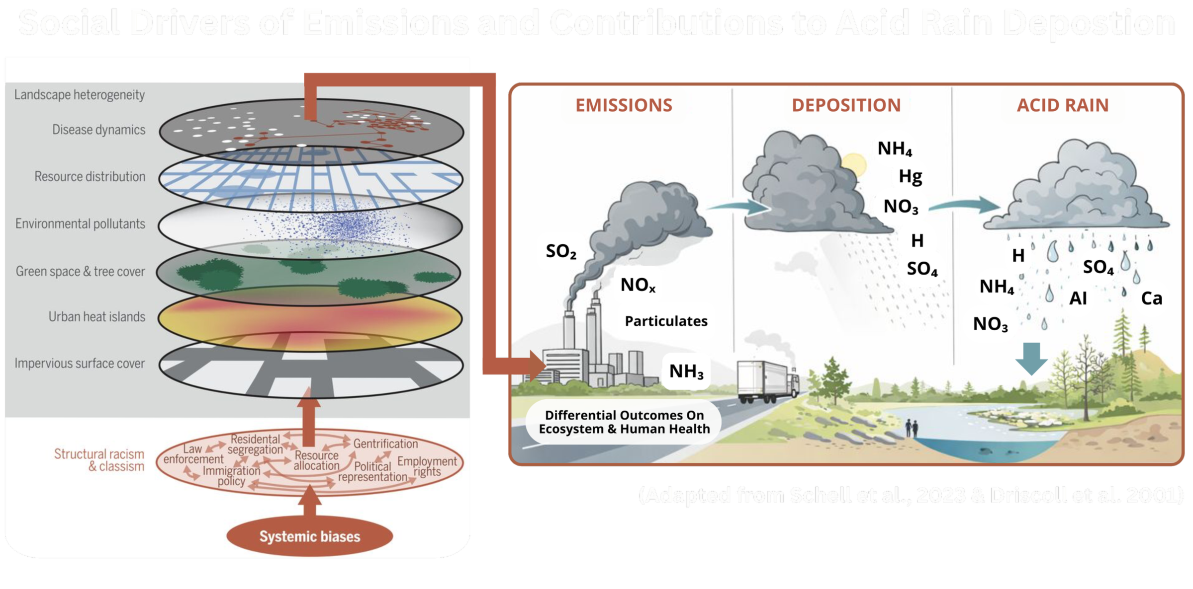
Figure: Conceptual model linking structural racism and classism to systemic biases that influence environmental land-use (e.g., green space, heat islands, pollutant exposure), and in turn, geographies of emissions (SO₂ & NOₓ concentrations), their atmospheric transport and resulting acid deposition, and ultimately drive long term ecological and biogeochemical change.
To answer this, facility locations and emissions of key states that contribute to acid deposition at HBEF were mapped alongside two measures of inequality. The first measure was historical redlining, a U.S. federal practice that racially graded neighborhoods and drove decades of investment and disinvestment; these maps, digitized by the Mapping Inequality Project, still reveal where pollution exposure, public health risk, and material deprivation concentrate nearly a century later. The second measure was social vulnerability, which quantifies how demographic and socioeconomic factors (e.g., poverty, disability, housing insecurity, etc.) influence community risks across spatial scales, as captured by the CDC's Social Vulnerability Index. Using the U.S. EPA’s National Emissions Inventory, his research compared the number of major NOₓ and SO₂-emitting facilities and concentrations of emissions across historical redlining grades and present-day vulnerability levels. Results showed that the lowest-graded neighborhoods (C and D) contained a higher number of major emitting facilities and higher average emissions per facility, while communities with greater social vulnerability experienced the highest total emissions. Demonstrating that the emissions linked to long-term changes in forest ecosystem function are concentrated in places structured by inequality and vulnerability. These findings show how history continues to structure patterns of environmental harm today, and why addressing inequality is inseparable from ecosystem remediation, because reducing pollution at its source requires confronting the social systems that determine where emissions concentrate.
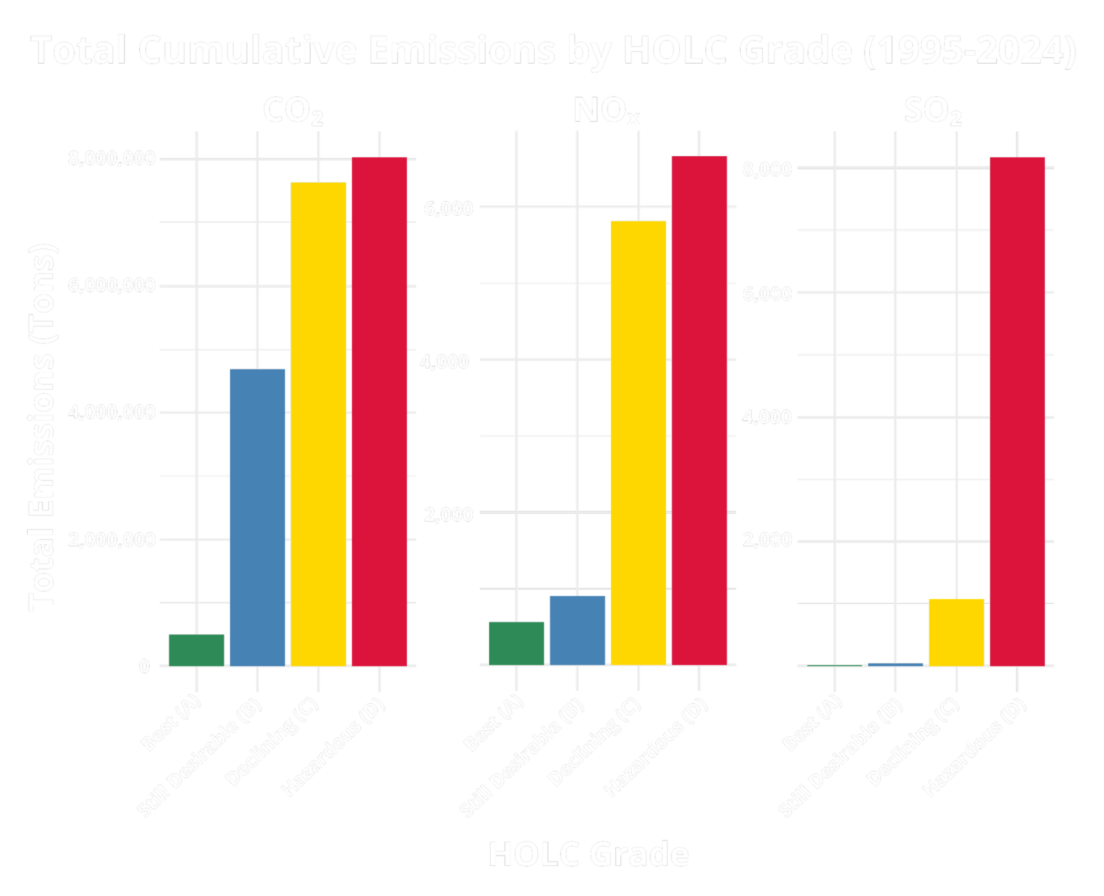
Figure: Total cumulative CO₂, NOₓ, and SO₂ emissions summed across facilities located within HOLC-graded neighborhoods, showing the highest cumulative emissions associated with areas historically graded C (“Declining”) and D (“Hazardous”). Data sourced from EPA National Emissions Inventory & Mapping Inequality, code and repository on GitHub [Link].
Policy-Engaged Research
My experience at the science-policy interface centers on translating environmental research into policy- and decision-relevant evidence, particularly in service of communities disproportionately burdened by environmental harm. Across federal agencies, private firms, and interdisciplinary research programs, I have conducted applied research that contributes to environmental regulation, restoration, and ecosystem-based management. This research has strengthened my expertise to not only document compliance and quantify environmental harm, but to also produce the technical reports, regulatory documentation, and legal and policy briefs needed to advance accountability, guide decision-making, and inform remediation strategies that protect ecosystem and community health.
Science-Policy & Environmental Governance


UCLA Leaders in Sustainability Graduate Program
Interdisciplinary graduate training that connects sustainability research with leadership, policy, and real-world decision contexts across disciplines. This program has enabled coursework across environmental policy and law, strengthening the ability to translate scientific evidence into legislative tools to enact change at structural levels.
NSF Science-Policy National Research Traineeship
Evaluated complex marine policy issues through integrated social and environmental lenses within an interdisciplinary graduate curriculum alongside ocean scientists, Indigenous tribal leaders, and policymakers. Training emphasized “use-informed” science and the co-production of knowledge, strengthening the ability to bridge environmental research with the politics surrounding environmental decision-making.
Environmental Compliance & Remediation
National Oceanic and Atmospheric Administration, Research Intern
Contributed to a Natural Resource Damage Assessment (NRDA) by applying ecotoxicological methods to assess fish populations in an urban estuary and quantify injury from industrial contaminants. This work generated clear histological evidence of harm, strengthening the scientific basis for corporate accountability and informing remediation and restoration strategies to support ecosystem recovery.
Eco-Alpha Environmental Services, Environmental Technician
Supported water quality compliance monitoring within a private environmental consulting setting through procedural development, field operations coordination, equipment procurement, and regulatory reporting. Conducted field-based water quality sampling across municipal and industrial facilities, testing for contaminants under the Clean Water Act and producing CEQA-aligned documentation to support California State Water Resources Control Board requirements.
Critical Theory as Scientific Intervention
Independent Research
Ecological and evolutionary theories are shaped by the societies that produce them, and critical theory provides a lens to examine how scientific theories and frameworks reflect the social attitudes of their time. My independent research explores how those attitudes influence scientific “objectivity,” for example, tracing how dominant economic and political ideologies have historically elevated competition-centered narratives (e.g., Spencer’s “Survival of the Fittest") while sidelining evidence for cooperation (e.g., Kropotkin’s "Mutual Aid") and alternative frameworks for social behavior and reproduction (e.g., Roughgarden’s “Social Selection Theory”). To investigate this further, my independent research centers queering ecology and evolution as both critique and method. It examines how queer people have been historically positioned in science as objects of study, treated as deviations to be explained rather than subjects shaping the production of knowledge. By queering ecology and evolution, lived experience becomes an epistemological intervention, a way of asking different questions and recognizing how the facts of nature often falsify the prevailing theories. Drawing on queer ecology and critical theory, this research interrogates how assumptions about what is “natural” impacts what questions are asked, how patterns are interpreted, and which theories become normalized. By accounting for the diversity of sex and reproductive strategies across life, this research challenges reductionist, binary, and deterministic thinking and advances a more accurate ecological and evolutionary science that reflects the world as it is.